 April 13th, 2011 at 8:22 pm by Bill Steffen under Bill's Blog, Weather


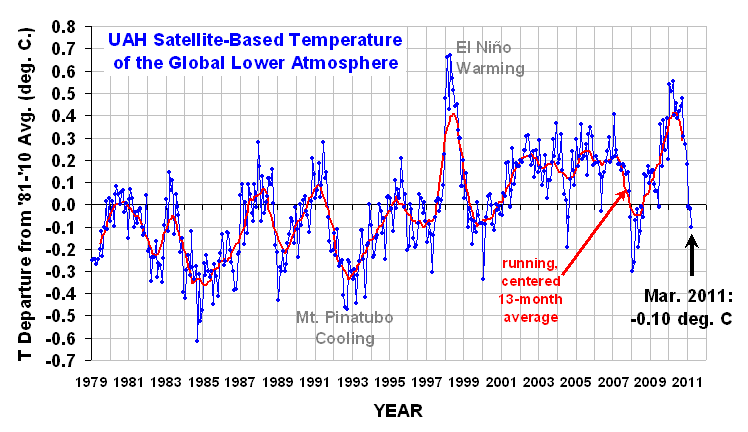
<–click on the graphics to enlarge or
click here for the first graphic and
click here for the 2nd graphic.
Global temperatures were colder in March 2011 than in any March since 1994. The Northern Hemisphere, the Southern Hemisphere and the Tropics all had colder than average temperatures in March. Temperature differences in March from average: Muskegon -0.8°, Grand Rapids -0.9°, Holland -1.1°, Battle Creek -1.2°, Lansing -1.3°, Kalamazoo -1.5°, Ann Arbor -2.8°, Ludington -3.4°, Houghton Lake -3.7° (Houghton Lake had a continuous snow cover of 2″ or more from Dec. 8th through April 9th or 123 days), Gaylord -5.0° and Manistee -5.5°. Global temperatures have been dropping since June 2010 in response to the La Nina/cold PDO. Here’s the
North Pole icecap graph. The graph shows that current ice is closer to the April average than the low year of 2007 and that the melt has barely begun this year. In fact, Barrow Alaska had a high of 2 above zero on Tuesday, which was the warmest day of the month so far. It’s hard to melt ice with temperatures like that. Bettles, Alaska had a record low temperature of -20 Tuesday morning. They are -6.5 below average for April so far. Kotzebue, Alaska still has 62″ of snow on the ground! Here’s the
current North American snow cover. Canada is still about 85% snow covered and there is above average snow on the ground in the higher elevations of both the Western mountains and New England. The town of
Resolute, Canada reports that the average temperature for April so far has been -21°F and the average temperature at the town of
Alert has been -23.8°F. It’s hard to melt ice with temperatures like that. One more thing…check out the
latest global sea surface temperature anomalies. You can see the cold PDO (cold water in the shape of a backwards “C” off the West Coast of the U.S., the weakening La Nina (warmer water developing along the Equator west of S. America), the warm AMO (warm water in the shape of a backwards “C”) in the Atlantic Ocean), the warm water in the Gulf of Mexico (which will lead to more severe weather this spring from southern Michigan to the northern Gulf States and also to an increased number of hurricanes his late summer/fall – which is typical for La Nina).

 <–click on the graphics to enlarge or click here for the first graphic and click here for the 2nd graphic. Global temperatures were colder in March 2011 than in any March since 1994. The Northern Hemisphere, the Southern Hemisphere and the Tropics all had colder than average temperatures in March. Temperature differences in March from average: Muskegon -0.8°, Grand Rapids -0.9°, Holland -1.1°, Battle Creek -1.2°, Lansing -1.3°, Kalamazoo -1.5°, Ann Arbor -2.8°, Ludington -3.4°, Houghton Lake -3.7° (Houghton Lake had a continuous snow cover of 2″ or more from Dec. 8th through April 9th or 123 days), Gaylord -5.0° and Manistee -5.5°. Global temperatures have been dropping since June 2010 in response to the La Nina/cold PDO. Here’s the North Pole icecap graph. The graph shows that current ice is closer to the April average than the low year of 2007 and that the melt has barely begun this year. In fact, Barrow Alaska had a high of 2 above zero on Tuesday, which was the warmest day of the month so far. It’s hard to melt ice with temperatures like that. Bettles, Alaska had a record low temperature of -20 Tuesday morning. They are -6.5 below average for April so far. Kotzebue, Alaska still has 62″ of snow on the ground! Here’s the current North American snow cover. Canada is still about 85% snow covered and there is above average snow on the ground in the higher elevations of both the Western mountains and New England. The town of Resolute, Canada reports that the average temperature for April so far has been -21°F and the average temperature at the town of Alert has been -23.8°F. It’s hard to melt ice with temperatures like that. One more thing…check out the latest global sea surface temperature anomalies. You can see the cold PDO (cold water in the shape of a backwards “C” off the West Coast of the U.S., the weakening La Nina (warmer water developing along the Equator west of S. America), the warm AMO (warm water in the shape of a backwards “C”) in the Atlantic Ocean), the warm water in the Gulf of Mexico (which will lead to more severe weather this spring from southern Michigan to the northern Gulf States and also to an increased number of hurricanes his late summer/fall – which is typical for La Nina).
No comments:
Post a Comment